Browns Bay Scenic Route
Length of Drive
17 miles / 27 kilometers
Route Description
Islandmagee or 'Browns Bay Scenic Route' is a two way (line in the middle) 'B' road with smaller, passable, single lane access roads to locations such as Portmuck (optional). The road is good for most of its length with some windy sections and blind junctions. Exceptional views, beaches, harbours, walks and the famous Gobbins Cliff Path (book in advance). It is signposted on the main Causeway Coastal Route near Whitehead where the loop starts and finishes.
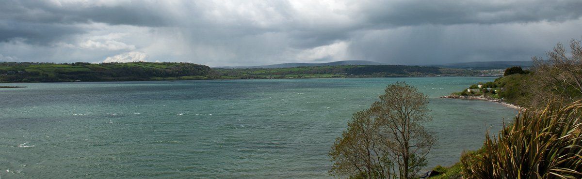
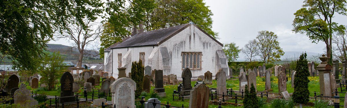
Islandmagee is referred to as the forgotten island, a unique peninsula steeped in history which goes back the first habitation after the last ice age. The drive turns off at a junction near Whitehead and is signposted as Brown's Bay Scenic Route ( the opposite road goes to Ballycarry). The drive takes you along the lough side to Ballylumford which is separated by a short stretch of water from Larne harbour. The modern name comes from the Magee family who had rights to the island under the O’Neills. The original name, however, is derived from the Gaelic ‘Inis Seimhne’, Seimhne being the tribe that once inhabited the island. As you drive the Low Road toward Ballylumford you will come to St John’s Church at Ballyharry (on the left-hand side). Founded in 1575 it succeeded the older church of St. John's in the townland of Ballykeel. The 12th-century graveyard is still there overlooking Old Church Bay.
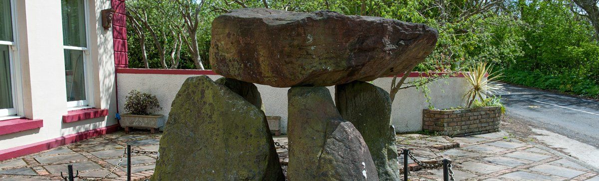
Further along on the right-hand side in front of an Edwardian House you will find the Ballylumford Dolmen, the remains of a portal tomb dating to the Neolithic period (circa 4000BC). This classic 'dolmen' is one of the best examples in the area and unlike many that are off the beaten track, it is very easy to view. Excavations on Islandmagee have uncovered evidence of Neolithic settlements, finds include pottery, flint arrowheads, javelin heads, polished stone and axe fragments. Saint Patrick also left a mark on the island in the foundation of Kilcoan Church (Cille Caomhán) which carries the name of one of his disciples Caomhán who become known as St. Caomhán. He is believed to be buried at Kilcoan or nearby in the Ross graveyard, today hardly anything remains of these two ancient churches. The island is very rich in ecclesiastical sites dating from the 6th century, some you can see others have over time vanished below the vegetation.
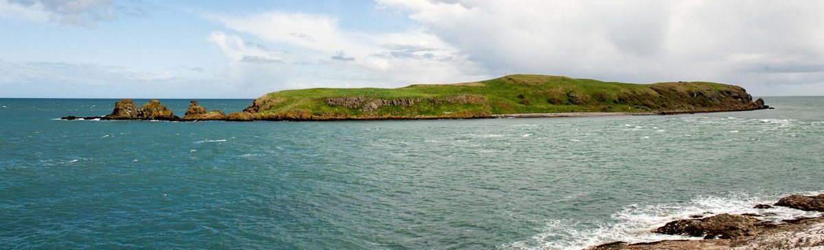
From Ballylumford you pass Larne Golf Club to Brown’s Bay, a popular summer location for recreation, swimming and walks around the headlands. The bay sweeps round to Skernaghan Point, a path which follows the shore passes the now still 'Rocking Stone'. This huge rock weighs over ten tons and at one time it could be rocked by hand. It became a big attraction during the Victorian era appearing on postcards during the late 1800s, unfortunately, the local authority decided it did not meet Health & Safety regulations and cemented it in place. After Browns Bay lookout for the turnoff to Portmuck (optional), there is a long history of trading between here and Scotland, in fact, one of the many Ulster livestock trails ended at Portmuck where thewy were exported to Scotland.
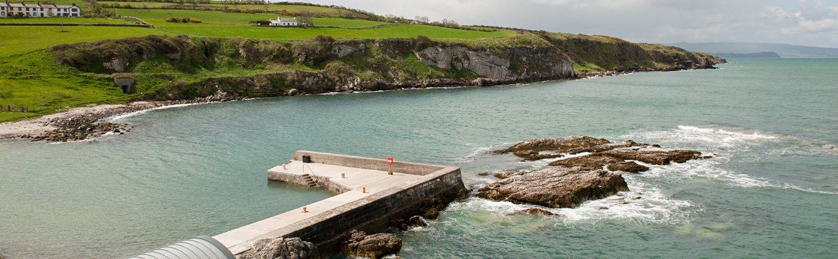
The site had a medieval settlement overlooking Muck Island ( Inis Muc ) or Pig Island. Excavations of the graveyard established that burials took place here as far back as the 6th century. During the 15th century, the harbour would have been one of the main routes to Scotland protected by a castle keep. It was renown for smuggling in the 18th century when there was a dramatic increase in coastguard and customs personnel. You can enjoy some beautiful walks and scenery around here, the inlet between Muck Island and the mainland attracts dolphins and porpoises, the island has a vibrant seal colony and is also the second-largest bird nesting colony in Northern Ireland with Kittiwakes, Razorbills, Black Guillemots and Guillemots.
The land, paths and stiles are managed by the National Trust for public access. The name Muck (Muc) means pig. The large lough between Islandmagee and the mainland provided valuable sheltered for those that ruled the lands around here which over the centuries has included the Celts, Vikings, Normans, Scots and English. The Vikings had a burial ground on the island and gave the lough its original name of Wulsrichefiord, later it became known as Olderfleet, today it is known locally as Larne Lough and has two small but important breeding birds. Olderfleet Castle is situated at Curran Point on the Larne side of the inlet and was built in the 13th century by the Scots/Irish Bissett family as strategic protection for the lough and Larne.
It was here in 1315 that Edward the Bruce (brother of Robert) landed with 6000 troops at the request of the Irish gentry, he subsequently took the country and was crowned king. At this time the Bisset's had the rights to Islandmagee, later, in 1399, Margery Bissett (Byset) the sole Bissett heir married John Mor MacDonnell which brought the presence of the MacDonnell clan to the north coast. In 1610, the island was granted to Sir Arthur Chichester who leased it to Sir Moses Hill, he had arrived in Ireland with the Earl of Essex in 1573. This area was highly regarded by Queen Elizabeth and her advisors as being of strategic importance and this fact is reflected in Moses Hill being assigned Governor of Olderfleet Castle.
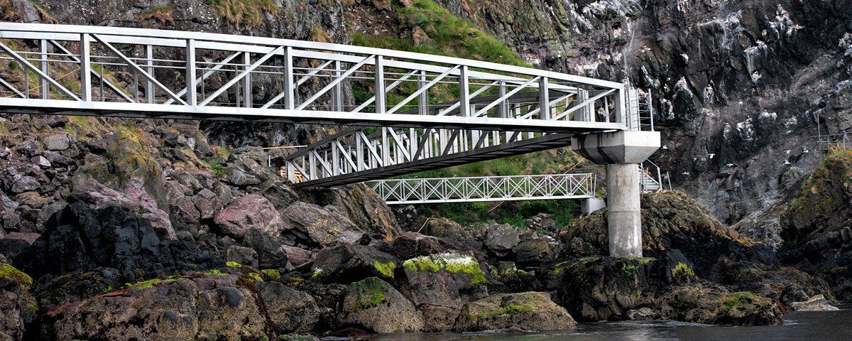
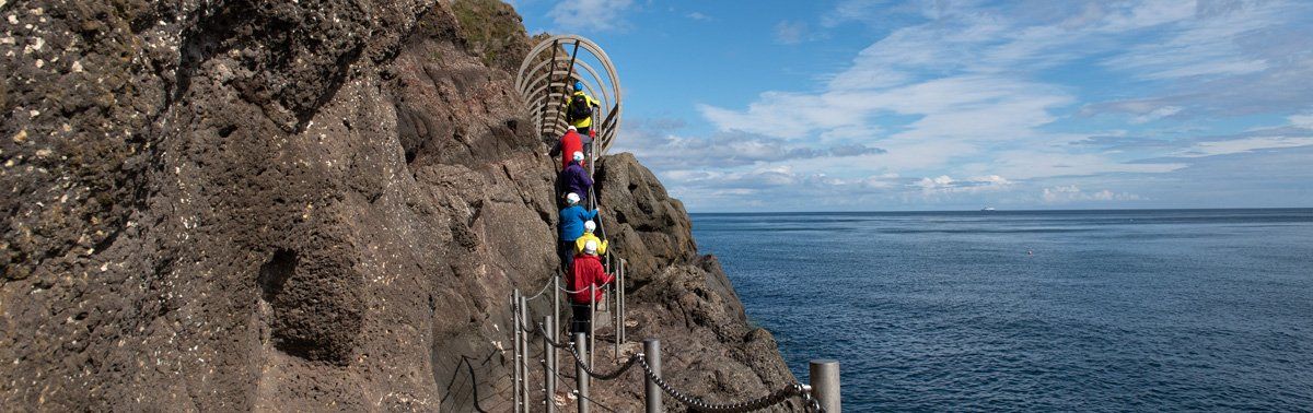
He married Alice MacDonnell the sister of Sorley Boy MacDonnell of Dunluce and eventually became Provost Marshall of Ulster in 1617. Islandmagee is an extremely interesting area to explore with lots of small clachans scattered over a network of country roads, it is also home to the amazing Gobbins Cliff Path, one of the main attractions in Ireland during Victorian times when trains would bring visitors into Whitehead. The Gobbins was a walk designed by Berkeley Deane Wise around the base of the sea cliffs, it went over chasms, through caves and along a path cut into the cliff face, all joined together by a series of footbridges and tunnels. After decades of abandonment and closure, the path is once again open to the public. (booking in advance is essential)