Crossing Carrick a Rede Rope Bridge.....
'Rock in the Road' is the closest translation in English we have for Carrick a Rede the origin of which comes from the Scots Gaelic 'Carraig a Rade', the island today is one of the key attractions along the Causeway Coastal Route but what does the name reveal to us? The 'Rock' is the island in the 'Road' or the way of migrating salmon as they navigate around the coast back to the rivers of their origin, a yearly journey which has been taking place for thousands of years.
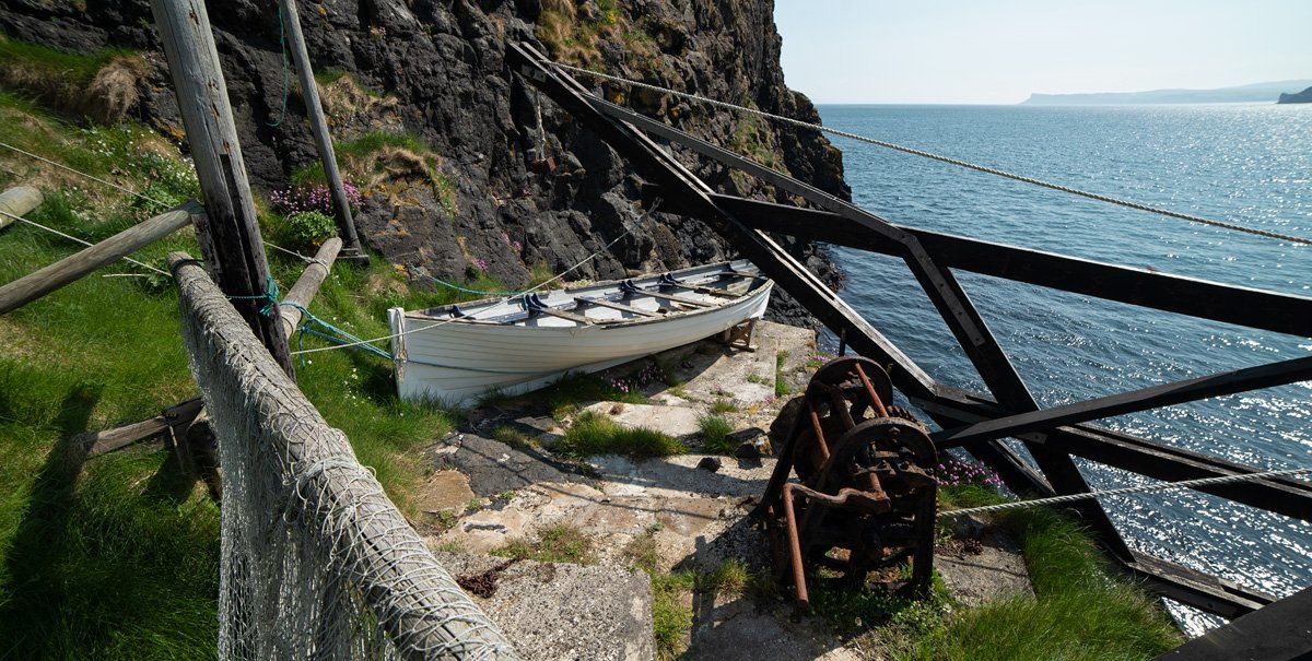
Carrick a Rede has been one of the prime locations for netting salmon since the mid-1600s, before the rope bridge was erected the boatmen would row from Larry Bane and Ballintoy to set their nets. The bridge constructed in 1755 made it easier to access the island and create a permanent base for their equipment which included a bothy, winch and a drontheim boat from which the nets were set and tended. From here the caught salmon would be carried across the bridge to the ice-house on the Ice's Brae, on the main road just before you reach Portaneevey car park.
Carrick a Rede has been one of the prime locations for netting salmon since the mid-1600s, before the rope bridge was erected the boatmen would row from Larry Bane and Ballintoy to set their nets. The bridge constructed in 1755 made it easier to access the island and create a permanent base for their equipment which included a bothy, winch and a drontheim boat from which the nets were set and tended. From here the caught salmon would be carried across the bridge to the ice-house on the Ice's Brae, on the main road just before you reach Portaneevey car park.
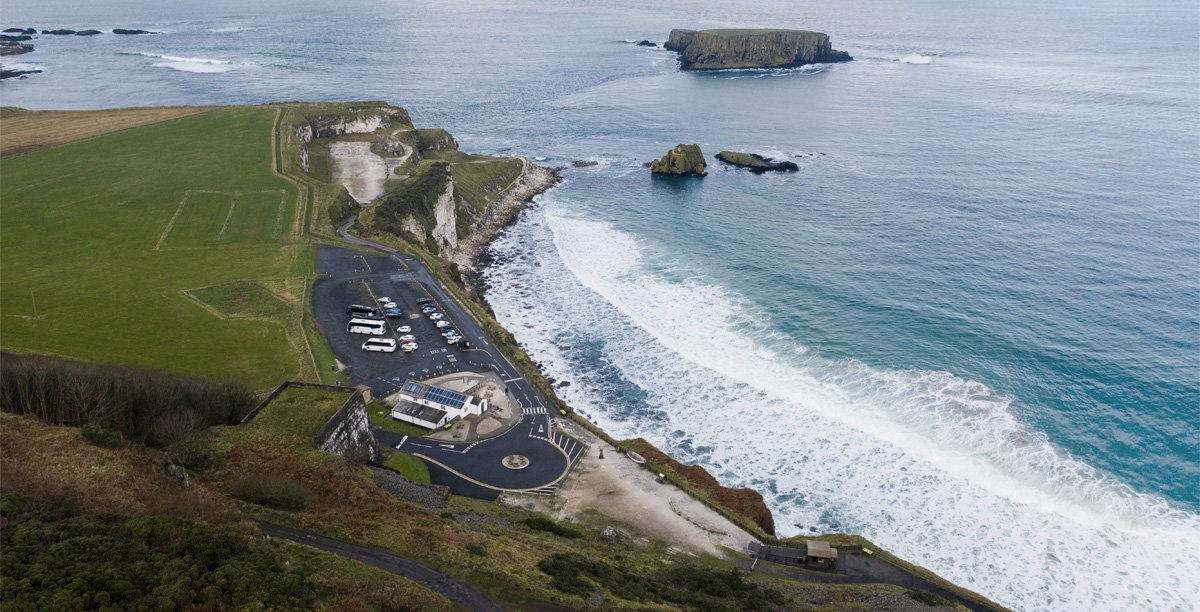
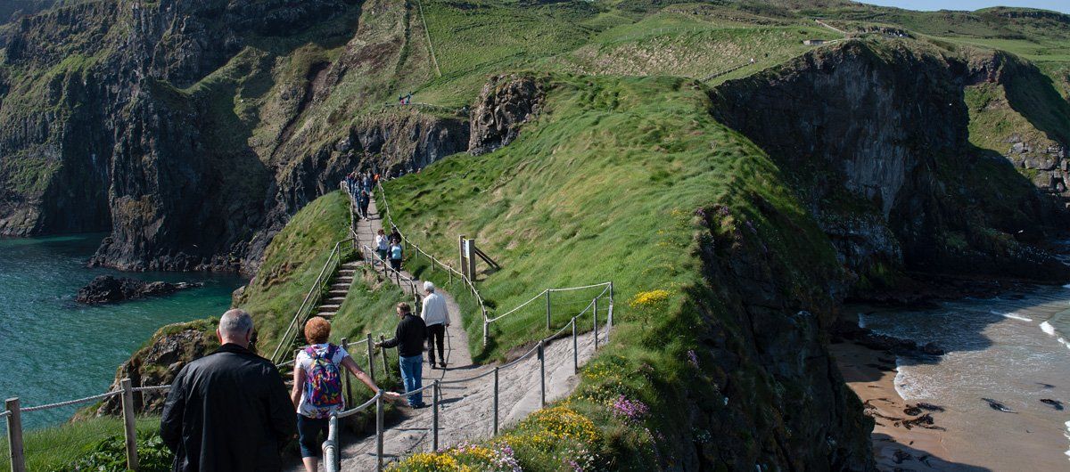
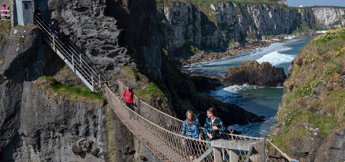
As you turn into the entrance to Carrick a Rede you descend down into what was a limestone quarry, past a large lime kiln overlooked by the basalt quarry of Brockie. The lower limestone quarry ceased operations in the early 1960s. A few years large the National Trust became custodians of the site and over following years made improvements for visitors by providing a tea room, shop and toilets where the old quarry weighbridge existed. The National Trust in the mid-1980s created a 1 km cliff top access path from the quarry reception area around Larry Bane Bay to the rope bridge, this replaced the old access path from the main road on the Ice's Brae.
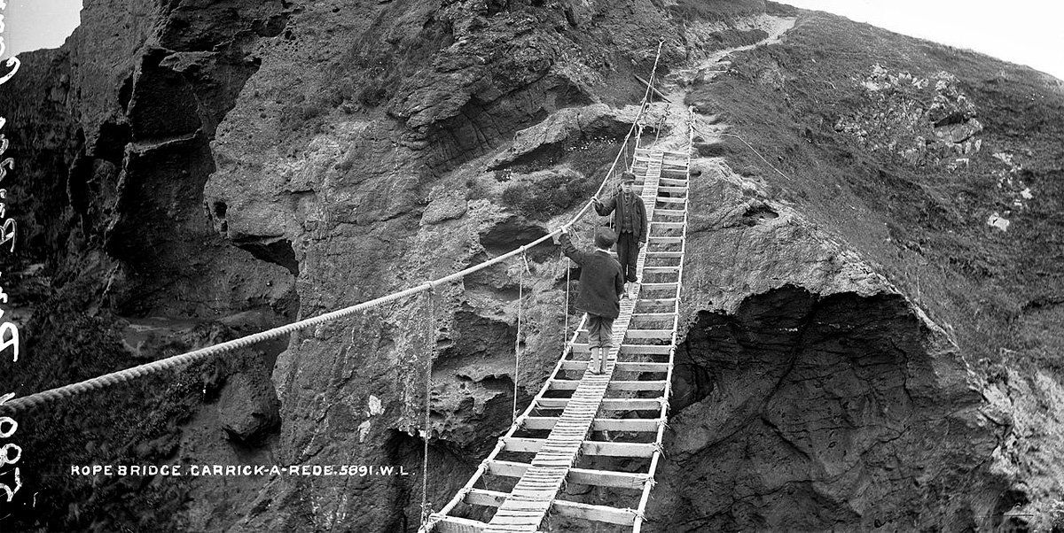
What is surprising, considering the basic construction of early bridges, is the fact that from its first use in 1755, there are no records of anyone losing their life by slipping off the bridge, considering that the fishermen and their carriers would have crossed it thousands of times carrying boxes of salmon or equipment, and in the past decades' tens of thousands of visitors have cross the bridge each year, it is remarkable that no-one has fallen off.
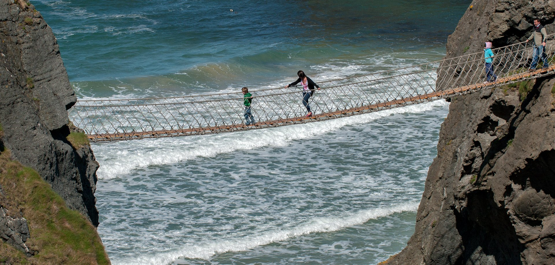
Today's bridge is a model of health and safety perfection which apparently will comfortably carry the weight of a double-deck bus which is reassuring to know when you walk across it. The bridge I first set foot on had two handrails like in the photo below but there was no netting either side or below the slats supporting the planking, instead there were stay ropes every metre or so with gaps of nothingness in-between, the one scary element I will never forget from my first experience crossing it.
Today's bridge is a model of health and safety perfection which apparently will comfortably carry the weight of a double-deck bus which is reassuring to know when you walk across it. The bridge I first set foot on had two handrails like in the photo below but there was no netting either side or below the slats supporting the planking, instead there were stay ropes every metre or so with gaps of nothingness in-between, the one scary element I will never forget from my first experience crossing it.
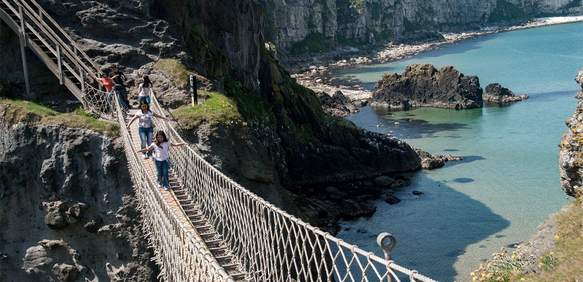
I was around eight or nine years old and came up to my uncle's elbows in height, my eyes were level with the top ropes. I still have a vivid memory of holding the ropes with my arms outstretched like the young girl in the picture above, and feeling the moving and bounce of the bridge below my feet as I kept close behind my uncle. As we walked across I was looking down at the back of his boots and trying to keep my step with his, at the same time nervously catching glimpses through the slats of the ocean 100 feet (30m) below.
Every few steps my hands would feel the stay ropes which came down from the top handrails on either side, offering a momentary sense of security, they extend down to the supporting rope rails that carry the slats on which the foot planking lay. These stays were the only element of safety between me and the nothingness either side. On reaching the island there was a great feeling of relief, security and an island to explore but in the back of my mind was the thought of going back across, as it looked more precipitous against the high cliff.
Every few steps my hands would feel the stay ropes which came down from the top handrails on either side, offering a momentary sense of security, they extend down to the supporting rope rails that carry the slats on which the foot planking lay. These stays were the only element of safety between me and the nothingness either side. On reaching the island there was a great feeling of relief, security and an island to explore but in the back of my mind was the thought of going back across, as it looked more precipitous against the high cliff.
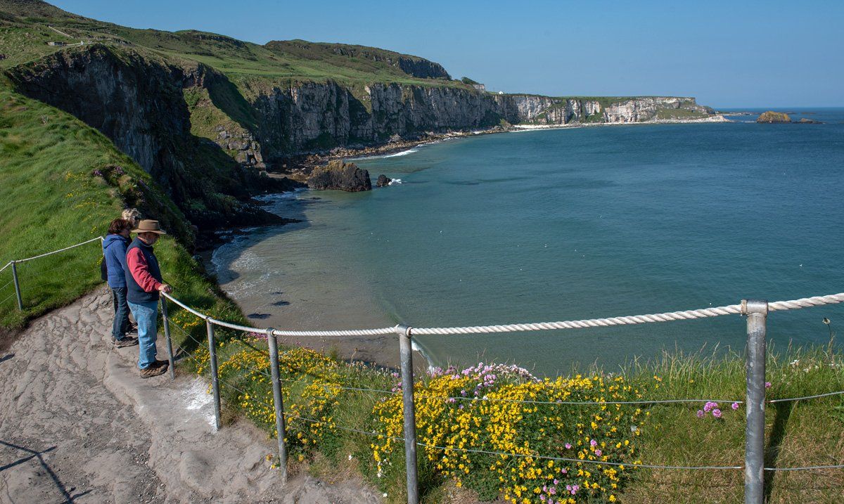
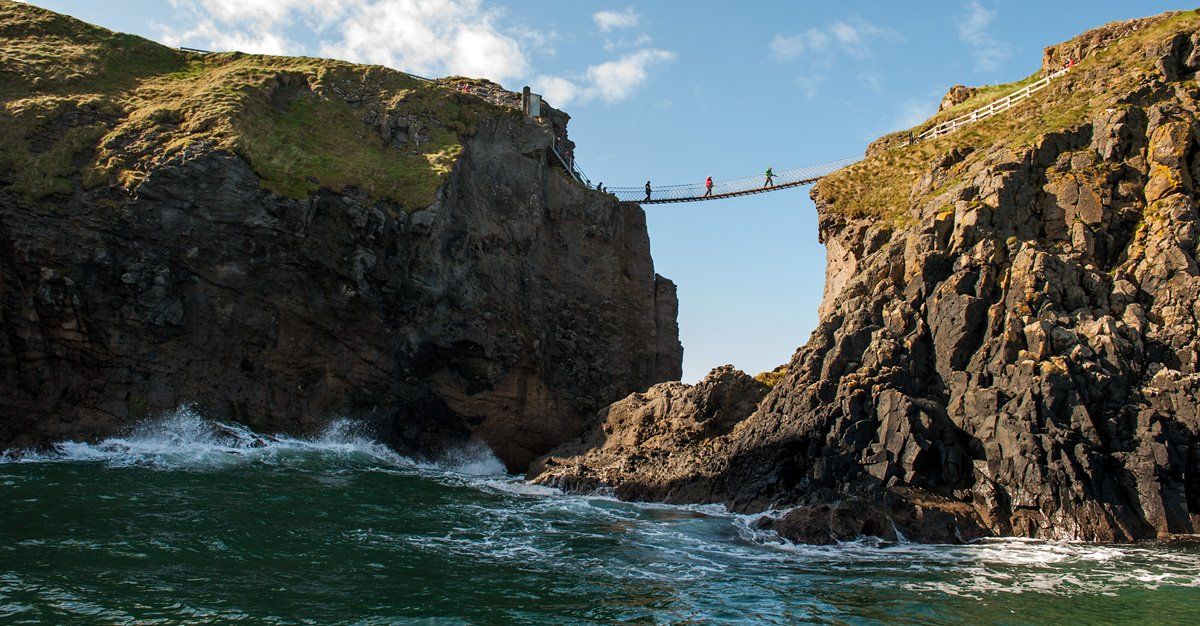
Once you reach the island the paths are very natural with safe public zones delineated by ropes, in places you are surrounded by high and dangerous cliffs, so if you are taking young people across then it is good to be fully aware of this and know that a roped area means 'out of bounds' so up your supervision level accordingly, there are also safety signage to warn you. The views though are truly wonderful from all angles, the gorgeous sweep of Larry Bane Bay on one side and on the other the high cliffs of Portaneevey stretching along to the Giants Cut and around to Kinbane Head. On a clear day, you get a panoramic view which takes in Fair Head, Rathin and Sheep Island with the backdrop of the Mull of Kintyre and the Scottish Islands.
Before you set out for the island you should be aware that there are no toilets nor any shelter once you leave the reception area. If the weather is variable it can turn bad so advisable to carry a waterproof coat, from experience, getting caught out without one can be a horrendous experience.
Before you set out for the island you should be aware that there are no toilets nor any shelter once you leave the reception area. If the weather is variable it can turn bad so advisable to carry a waterproof coat, from experience, getting caught out without one can be a horrendous experience.
If you have a dog then they are welcome on site but are not allowed over the rope bridge and must be kept on a lead at all times, the same applies to an assistant guide dog. To visit and walk around the paths is free but if you wish to cross the bridge you will have to pay and to do that it is essential to book a time ticket in advance for your visit, especially during the holiday season. I will come back to this at the end of the post.
From the path you can look down to the restored fishermen's bothy nestled in the sheltered lee of the island, this served as a 'home from home', workshop and shelter for the fishermen while on the island, from here they reached the boat by a series of steps leading down to the water's edge, the boat would be lowered down by the winch which is still in situ. The bothy area remains like it was when salmon fishing halted here in 2002. Open days are held when the public can visit the bothy and there is also a bookable high-end tour which includes a visit to the bothy.
From the path you can look down to the restored fishermen's bothy nestled in the sheltered lee of the island, this served as a 'home from home', workshop and shelter for the fishermen while on the island, from here they reached the boat by a series of steps leading down to the water's edge, the boat would be lowered down by the winch which is still in situ. The bothy area remains like it was when salmon fishing halted here in 2002. Open days are held when the public can visit the bothy and there is also a bookable high-end tour which includes a visit to the bothy.
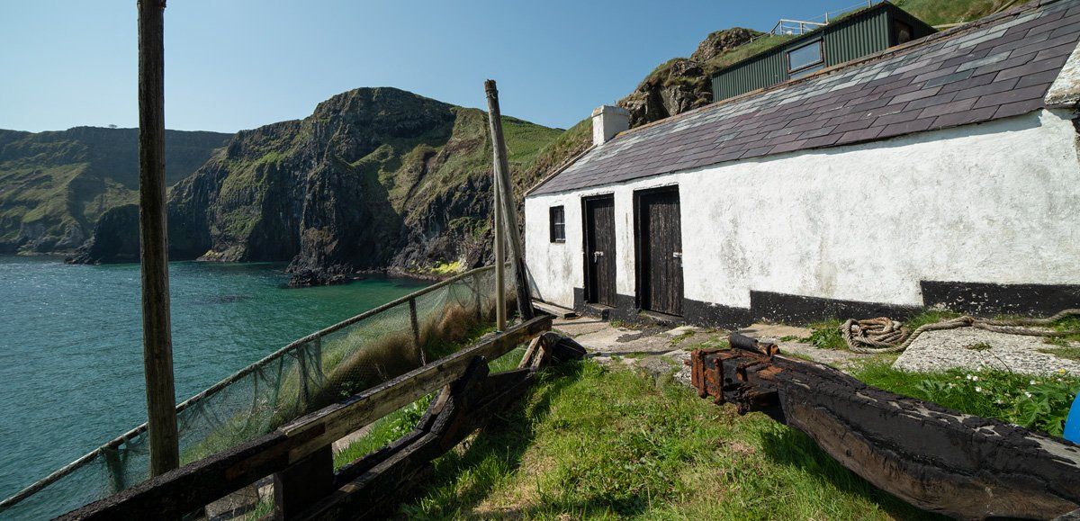
Whenever I go down there and immerse in the stillness surrounded by all the associated parts of the fishery, I almost expect to see a fishermen coming down the steps or emerging from the inside the bothy. It is amazing when you realise the salmon industry on this wee island sustained the lives of numerous local families whose descendants still live locally. Records show that during the 1800s there were 21 salmon fishermen and 10 carriers living in and around Ballintoy, not to mention the fishermen who worked from Ballintoy harbour. The salmon was plentiful, up to 300 a day were being caught here.
Catches were good until the early sixties after which they went into decline, during the final season only 250 salmon were caught, the site became non-viable and ceased operation. A lot of blame for this is with the introduction of large factory ships that catch wild salmon as both a primary catch and as a secondary catch with other fish. This factory processing model played a role in depleting the wild stock of Atlantic salmon, this, in turn, led to the decline and the end, thorough government action, of all salmon fishing not only at Carrick a Rede but around the north coast.
Catches were good until the early sixties after which they went into decline, during the final season only 250 salmon were caught, the site became non-viable and ceased operation. A lot of blame for this is with the introduction of large factory ships that catch wild salmon as both a primary catch and as a secondary catch with other fish. This factory processing model played a role in depleting the wild stock of Atlantic salmon, this, in turn, led to the decline and the end, thorough government action, of all salmon fishing not only at Carrick a Rede but around the north coast.
The 1km walk from the reception area is pleasant with rest point seating and viewpoints along the way but there is a steep climb and descent by a long series of steps on the main path as you near the island. It is a good idea to wear appropriate footwear as you will be walking on compacted gravel paths, stone steps and in places with uneven ground, the final short descent to the bridge is down a very steep set of metal steps.
As well as spectacular views there is also an abundance of wildlife to enjoy on the island, common seabirds which you will see include oystercatchers, guillemots, fulmars, razorbills and kittiwakes. Looking down into the clear water you can spot shoals of fish including salmon as they still seasonally migrate in smaller numbers around the island, you may also see other welcomed visitors like porpoises, dolphins, basking sharks and our common seal.
Outside of peak season, there is generally adequate parking facilities onsite which are free to use (you pay to cross the rope bridge), however, during peak season, it can fill to capacity which leaves you very few options for parking. One option is to use the large layby on the main Causeway Coastal Route.....as you leave the main entrance of Carrick a Rede turn left for Ballycastle and just around the first bend there is a large layby, you can park there for free, it is then a short walk back to the reception area.
Facilities on-site include toilets, a tea room and shop, these are small in size and on busy days you will encounter queues to get served in the tea room and also to use the toilets, this is exacerbated by the arrival and departure of 53 seater coaches. For wheelchair users, the main reception area is wheelchair accessible while the path to the rope bridge is only accessible for the first 0.5km and it is advisable to have an assistant with you. 400 metres along this path you will find a fully wheelchair accessible public viewing telescope, one of the first installed in Northern Ireland.
Facilities on-site include toilets, a tea room and shop, these are small in size and on busy days you will encounter queues to get served in the tea room and also to use the toilets, this is exacerbated by the arrival and departure of 53 seater coaches. For wheelchair users, the main reception area is wheelchair accessible while the path to the rope bridge is only accessible for the first 0.5km and it is advisable to have an assistant with you. 400 metres along this path you will find a fully wheelchair accessible public viewing telescope, one of the first installed in Northern Ireland.
As mentioned previously it is essential to book a time ticket for the rope bridge as from March on the footfall increases. You can do this online at the following location (https://giantscausewaytickets.com/carrick-a-rede-tickets), from March 2020 the charges are as follows:
Adult - £10.00 / Child (aged 5-17) - £5.00 / 2 Adults 1 Child (aged 5-17) - £25.00/ 2 Adults 2 Children (ages 5-17) - £25.00/ 2 Adults 3 Children (ages 5-17) - £25.00 / National Trust Member Adult - FREE / National Trust Member Child (aged 5-17) - FREE.
You can also add on a guided tour for an additional £3.50 per person.
The contact number and email for the National Trust at Carrick a Rede are: Tel: 028 2073 3335 Email: carrickarede@nationaltrust.org.uk
As well as visiting the rope bridge, a walk down into the old quarry will give you some exceptional views back along the cliffs to the rope bridge, in fact, if it is a busy day you may end up parking here as it functions as an overspill car park. The site was used by HBO for the filming of their Game of Thrones series but the heritage and history of the site is far more interesting and worth exploring. The location has connections to Wales through Welsh miners who came to work here.
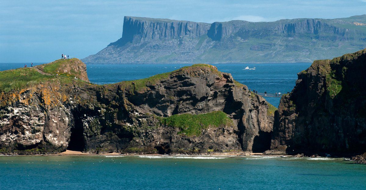
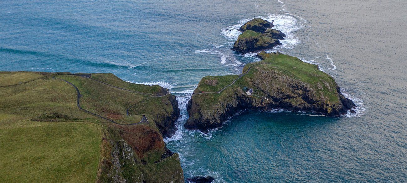
Before you leave or arrive at Carrick a Rede it is worth pulling into Portaneevey Car Park on the main Causeway Coastal Route located high above the island where you can get a spectacular view of Carrick a Rede from above (first image in the blog) as well as panoramic views across to Rathlin Island, the Mull of Kintyre in Scotland and the Scottish Isles of Jura and Islay, there is also a large bronze plaque which tells you the distances from this point to all the locations visible as well as across the Atlantic to the nearest landfall.
Enjoy your visit.......
Enjoy your visit.......